Sights
Ropotamo reserve

Located on an area of just over 1000.7 ha the reserve is a rare combination of beautiful scenery, spectacular landforms, a wide variety of coastal, forest and aquatic habitats of many rare and endangered plant and animal species and communities. On this small area there is a combination of the sea, a river, a marsh, deciduous and dense forest vegetation, various types of rock formations, beautiful beaches, as well as sand dunes, and all these natural resources are combined with many historical and archaeological findings.
A part of today's Ropotamo reserve was declared way back 1940 a place "to preserve the forest communities of dense forest type located along the eponymous river, which crosses the big sand dunes and flows into the Black Sea." Over the years the area changed its status repeatedly, but always remained a protected area. In the 1960s it was even a national park. The most recent categorization is from 1992 when it was declared a strict nature reserve "for the conservation of the unique flora and fauna along the coast near the mouth of the eponymous river." The reserve has an international status as part of the Ropotamo complex recognized as wetland of international importance under the Ramsar Convention, declared an Important Bird Area and a part of Ropotamo Complex Protected Area from Natura 2000 network.
This small area is home to a great biodiversity. For professionals in figures this means about 60% of the freshwater ichthyofauna of Bulgaria, 60% of the herpetofauna, 50% of the nesting avifauna, and 57% of the mammal species.
The reserve is a habitat for many rare animals. The European bird migration route Via Pontica passes through here. The large number of wetland zones in the area is a great base for many nesting birds as well as feeding grounds for wintering and migrating birds. The reserve hosts 226 species of birds (woodcocks, finches, thrushes, sandwich terns, plovers, wild geese whooper swans and mute swans, songbirds, herons, pelicans, ducks, sea eagles, hawks, vultures, etc.), 8 of which are globally endangered and 70 are included in the Red Book of Bulgaria.
The rocky areas and sand dunes are home to a lot of reptiles: Greek tortoise and Hermann's tortoise, leopard snake и Montpellier snake, Aesculapian snake and different lizards, and in the wet and marshy areas – turtles, long-eared and gray snakes, newts, green toads, brown toads, tree frogs and Balkan spadefoot toads.
The reserve is inhabited by 50 species of mammals. Among them are: red deer, fallow deer, roe deer, mouflons, foxes, jackals, otters and colonies of bats in the rock caves. Extinct mammal species are bears, wild cats and seal monks.
The ichthyofauna is represented by 14 species of fish which permanently inhabit the firth area ofthe river: pearl mullet, vimba bream, rudd, carp, silver carp, and chub. Many more species are registered as temporary inhabitants. These are the Black Sea and Begendik shad, the rainbow fish, etc.
600 species of vascular plants have been identified in the reserve, which is about 15% of all the flora of this country. There are preserved about 11% of the plant species included in the Red Book of Bulgaria, which is 83 species (71 rare, 11 endangered and one extinct). 16 species of vascular plants are endemic and 23 tree and shrub species are Tertiary relicts. On the territory of the reserve you can see elm, ash, maple, black alder, hornbeam, common clematis, hazel, sumac, ivy, flowering ash, oak, beech, willow, Thracian tulip, and spring snowflake. The marshes and spills are overgrown with reeds, bulrush, cattail, iris, tamariks, yellow pond-lily and white water lily. On the sand dunes there still grow the sand lily, the sea wormwood, the wild fennel, etc., which are typical of the South Black Sea coast.
St. Thomas Island
An interesting part of the reserve is the island of St. Thomas, better known as the Snake Island. It is located in Arkutino Bay. It is a nesting place for water birds, a habitat of Günther's vole and wild paddle cacti planted here in the 1930s.
Ropotamo has been a popular tourist destination in Bulgaria for many years.
One of the most visited tourist sites on the South Black Sea coast is Arkutino marsh with its beautiful white water lilies. For some of the foreign tourists they are nothing special because they are grown in almost every pond – in the back yard at home or in the city park. The value of the white water lilies here is that they are natural and grow in the wild.
A favourite attraction for holiday makers on the Black Sea is the boat trip from the dock of the Ropotamo River (under the bridge of E87) to the mouth of the river. It lasts 60 minutes. Herons and kingfishers fly past the tourists during the boat trip. Particularly attractive are the turtles which bask in the sun on the rocks or fallen trees on the river banks. Very interesting is the Lion's Head – a bizarre rock formation high above the right bank of the river. (лъвската глава)
Although it is a strict reserve (all human activities are prohibited here) – the boat trips along the Ropotamo River are one of the exceptions for the benefit of tourists. This activity is conceded by the Ministry of Environment and Water. Unfortunately, although this tourist attraction has been offered for many years and is still very popular among holiday makers on the Bulgarian Black Sea coast, nothing has yet been done to provide modern, non-motorized boats, which will help to guarantee that there will be no pollution and no noise.
Some other activities approved by Order of the Ministry of Environment and Water are the hiking trails for visitors to the reserve:
A trail bridge in Arkutino marsh;
A trail to Ropotamo River (a continuation of the asphalt road coming from Primorsko and passing by the former residence Perla);
A trail to St. Paraskeva bay;
A trail to the highest dune in the Balkan Peninsula (starting from the center of the Regional Inspectorate of Environment and Water);
A trail through Kaya cape to the mouth of Ropotamo River;
A trail to Veselata skala (unfortunately, no longer accessible after the latest road works – no exit where to stop)
A trail to the supported reserve Velyov Vir;
A river boat trip from the boat dock to the mouth of Ropotamo River and back.
Beglik Tash

is a prehistoric rock sanctuary situated on the southern Black Sea coast of Bulgaria, a few kilometers north of the city of Primorsko. It was re-used by the Thracian tribes in the Iron Age. The sanctuary consists of a central section and two smaller structures around it, with a total area of 6 decares (6000 sq.m). The large rocks were partially carved and assembled on the site; stone plates and blocks arranged by human hand in unique shapes. In the flat rocks there are carved stone circles, grooves and so called "Markovi stupki" (the steps of Marko). The small buildings and cult fireplaces back up the evidence of early human activity here.
At the end of the 19th century, the Czech-Bulgarian historian and archaeologist Karel Škorpil produced the first scientific account of the sanctuary, which was then known as Apostol Tash. In 2002, the Bulgarian archaeologists started excavating the place under the supervision of archaeologist Tsonia Drazheva.
Beglik Tash - an expression whose meaning is probably related to the tax on sheep collected by the Ottoman authorities until 1913, the "beglik", and a Turkish word to describe an area made of large stones, taşlar- is a natural phenomenon of huge megaliths arranged and carved by a Thracian tribe and later used for religious ceremonies. It is part of a wider surrounding area and a natural rock formation of huge monolithic blocks of volcanic origin, and were formed of hardened magma that erupted from a volcano active during the Mesozoic era.
Most of the megaliths have traces of carvings for the purposes of Thracian rituals. There are also the remains of a labyrinth that visitors can pass through. A Thracian sun clock is formed from huge stones. There is also a 150-ton rock that rests on the ground in only two places, and a "womb-cave". It was associated with the cult of fertility, the Mother Goddess, the orphic dedication and immortalization of the Hero.
Beglik Tash is the oldest and largest Thracian sanctuary in eastern Bulgaria. It spreads over approximately 12 ha as it consists of two circles formed by large rock formations and stone ensembles, each of them representing a single element or feat in the ritual of sacred marriage and commitment. The use of natural phenomena by the Thracians shows their utmost respect for what nature has created, with only few natural forms changed by human hand in order to engrave ritual symbols and signs.
An important element in the Thracian rituals is the water lit by the sun. So they created many water reservoirs associated with grooves, channels, basins to collect the holy water with which to perform the ritual of cleansing wash. Depending on the holiday, which they have come to worship, they brought gifts and performed offerings at different places in the sanctuary - at the entrance, at the so called marriage bed, sacrificial stones, the divine steps (cavities hewn in the stone in the shape of big foot prints), at the entrance to the dolmen - a model of the sacred cave or womb of the Mother Goddess, maze and more. Their offering to the Gods include fruits, flowers, sacrificial animals, wine, milk, honey, olive oil served in clay pots, which were ritually broken at the appropriate place to break the "lives" of these items so they can give new life ie to revive.
Inside it, archaeologists have found ceramic artefacts from the Early Iron Age (10th-6th century BC), the Antiquity, and the Middle Ages, as well as a man-made stone altar at the end of the natural cave which proves that it was used as a place of worship. Every day at noon, a ray of sunlight enters the narrow entrance of the cave, and projects itself on the back of cave. According to late Bulgarian archaeologist Prof. Alexander Fol some of the Thracian womb-caves had the property of letting the sunlight in only at certain times of the day, a natural phenomenon seen by the Thracians as acts of symbolic fertilization of the Earth womb or the Mother Goddess by the sun phallus of the Sun God.
The site is an open-air museum maintained by the Burgas Historical Society. It is visited annually by 40,000 tourists. Beglik Tash is located in the vicinity of two other Thracian sites: the city of Ranuli and the fortress ofPharmakida in the Strandhza mountain.
Ranuli

Ranuli (aka Azine) is the name of an ancient city, which ruins are situated close to the mouth of Ropotamo River where it goes into the Black Sea, 5.7 kilometers north-west of town of Primorsko.
There is a rocky hill , covered with green grass all over it, which is called The Lion Head, and it is exactly over the river` s mouth, and the fortress on it gave the beginning of the city. The city was built on this place because of the favorable climate and relief.
There are still walls of the fortress which are in a quite good shape, build from big and well shaped stones which are fencing an area of 30 000 square meters, and that turns the city into one of the biggest fortified cities in Bulgaria.
According to the structure of the building, the people dealing with researches refer the fortress to the epoch of Cryto - Mycenaean civilization which was 14-16 century B.C. There was life on that hill even before that but the massive construction had destroyed great part of the artifacts.
It is considered that on the time of the Roman Empire, this fortress was one of the most serious centers of the Black Sea.
Nowadays the fortress is also famous with the name Valchanovo kale, because it was used by Valchan voivode for a command post during the Ottoman Empire.
Urdoviza

The mysterious town of Urdoviza is dated 5th century B.C. when the Persian ruler Darious has settled his port here, protecting his empire from the Skit invaders from South Ukraine. After a long period of any evidence for the town, in 16th century it starts to appear in all Italian trade maps, proving it has gain international geopolitical importance again.
Another legend suggests that during the time of the Ottoman rule, the town was protected by a beautiful woman, called Stana. After several failed attempts by the Ottomans, the Sultan proposed the Bulgarian defender a marriage, stuck by the genius and bravery of the Bulgarian woman. The defender of the fortress communicated here conditions for accepting the marriage - her key request was preserving the area of Urdoviza in the Strandzha mountain as a free territory. Not only beautiful, but also wise the “White” Stana send several horse riders in the area around in order to create the illusion that it is much larger than the original. The wisdom of the young woman insured the peaceful life of 17 villiges since the Sultan held his promise, collectively called Hazekia , meaning the Sultans area until 1834.
The town of Urdoviza disappeared in the 18th century, following the destiny of large number of town at the seaside due to the strong Kazak invasions. The town has been forsaken for a long period of time, until in 2012 archeologists and historians restart their explorations.
Maslen nos

Maslen nos is a cape on the Black Sea, in southeastern Bulgaria. Maslen nos is the southernmost point of Burgas Bay.
This Cape is the easternmost point of the Saddle Mountain beach which ends here on a peninsula (north-south extent: about 4 km, east-west distance about 3 km) and projecting into the Black Sea. Immediately on the Cape is a steep rocky coast into the sea. Viewed from the north Maslen nos recalls the outline of a lion's head - not to be confused with the rock band "lion head" on the river Ropotamo.
On the cape is the chapel Sveti Nikola. Two miles north from the Cape Maslen nos is Cape Karaultasch.
The cape Maslen nos (example: "olive-bay") was the time of the Greeks notorious for many ships were wrecked here on the sharp rocks and went down. The cargo of these ships was in large part from amphorae with olive oil, then that clearly visible from the wrecked ships withdrew. Hence the name Maslen nos (maslo = fat, oil, nos = nose, cape).
During the 500 year rule of the Ottoman Empire over the region of present-day Bulgaria was called the Cape Zeytin Burnu, which means in Turkish "olive-bay" and even explicitly referred to olive oil and not generally to oil, such as the Bulgarian word "maslo. Zeytin (Turkish) = Зехтин (Bulgarian; transcription: Sechtin, borrowed from Turkish) = olive oil; burnu (Turkish) = nos (Bulgarian) = nose, ch
Not to be confused is the old Turkish name Zeytin Burnu with a same Zeytinburnu district in Istanbul.
The encountered in some atlases name "Cape Malsen nos" (English "cape Maslen nos") or "Nos Malsen nos" (abbreviated "N. Maslen nos") but is an incorrect Namespelling because of "nos" Bulgarian " cape "is. "Cape Malsen nos" would mean "Cape oily bay". The incorrect translation of "butter cape" (English "butter Cape") is to be found.
Lighthouse
From ancient and medieval nothing is handed on a lighthouse on Maslen nos. Because of its exposed location, the Cape but was certainly as early as the ancient navigational aid.
Initial information can be found in a Bulletin of the lighthouse authority in Istanbul on 6 December 1863. Herein requires the coordinates of a constant red lighthouse on the cape. The height of fire above the sea level was 10 m and visibility 6 NM. Probably saw this "lighthouse" exactly like the lighthouses on the Cape of Varna and the Isle of Sweta Anastasia. That is, it consisted of an iron post to which you put at dusk, a red light.
The company Julius Pintsch built in 1930 on the Cape a new lighthouse, which still stands there and does his service. At the lighthouse a lens of Julius Pintsch is mounted, which runs on gas.
The lighthouse is located 7 km north of Primorsko. His light above the water is 37.5 m above sea level. It has a range of 17 nautical miles (NM). 17.2 s all he sends three white Flash Mode (duration 0.4 seconds, flashes) from. Between them, a break of four, four and eight seconds. The lighthouse is a white, 6 m high (with the pedestal for the look: 7.5 m) round stone tower with a gallery. The optics have been manually turned on and rotated by a motor (a small membrane gas engine), the gas pressure of exploiting coal gas before it burned in the burner of the beacon. From 25 July 1932 was converted to automatic acetylene gas.
The lighthouse is the one-storey houses (one room with kitchen) of a lighthouse keeper. In the small bay, which is located south of the cape, 500 m from the Lighthouse was removed a small quay built of concrete, so that boats could create. For many years, was to supply the lighthouse with fuel and food across the sea, as the lighthouse, especially in winter, was completely cut off from the hinterland.
South of the lighthouse in 1937, a square, 3 m high, built in stone, on which a fog bell was installed in bronze, to warn the ships in fog. The drive mechanism for the bell was housed in the stone. He had to be wound manually and started. The bell rang then for two hours every 9 s two times. after each gong, there was a pause of 3 s or 6 s. The next 25 years then the conditioning and the lighthouse at the Cape remained unchanged.
The need for a radio beacon called for a fundamental modernization of the plant on Maslen nos. The principal aim was a power line added to the lighthouse.
were built as 1961 from the Bulgarian and Romanian Black Sea coast 6 radio beacon, was one here.
The 6 radio beacon were at Cape following: Cape Kaliakra Snake Island Sveti Georgi Constanta Cape Emine Cape Maslen nos
These 6 beacons have successively broadcast their signals for one minute (including identification), so that repeated the sequence of all beacons every 6 minutes.
From 1961 the beacon sent at 24-hour operation, the letters "MN" from. The old look of the lighthouse was electrified. In 1968, the appearance of a modern electric Optics M-300 has been replaced. The old look can be seen since 1977 in the Marine Museum Warne (Bulgarian Военноморски музей Варна). In 2005 the lighthouse was the new look M-500. Underwater Archaeology [Edit]
In the small bay just southwest of the Cape In 1960 the Bulgarian underwater archeology, expedition leader was Ivan Galabow. The archaeological findings showed that in this small bay, which lay in the lee of the prevailing wind direction, in the 6th have sought refuge century BC small ships. There are numerous finds from the Late Antiquity and the Middle Ages (5th to 14th century).
Perla

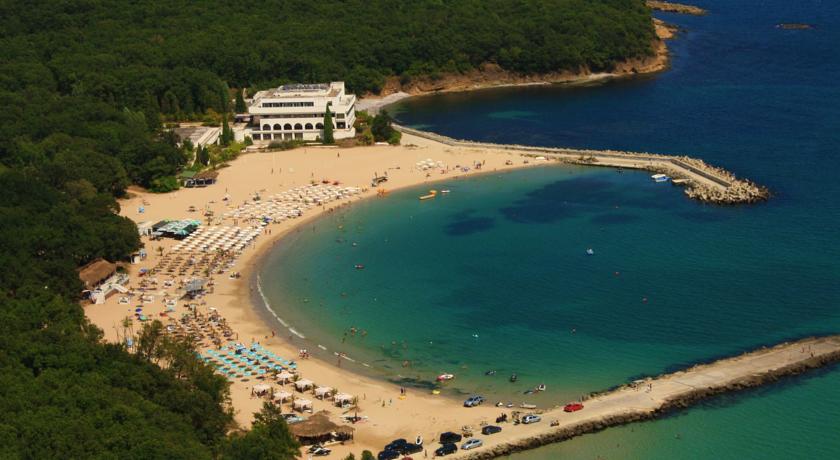
On the south side, 3.5 km from the Cape, is the former residence of Todor Zhivkov government, which was built around 1980. Since around 1955 there was a camp site in the middle of a dense oak forest. Before the democratic changes on November 10, 1989, this residence was famous for being the poshest of all the governmental resting homes. There is also small pier in front of the residence. Now this former luxurious site is totally abandoned. Perla today is not only fabulous place where the sea and a mountain meet, but also tells a story of time.
Sea promenade

A recently constructed pedestrian area surrounding the entire Peninsula is the newest meeting spot in Primorsko. The area is perfect for long romantic walks, biking, jogging, star-gazing. The promenade is several kilometers long and runs along the sea cost.
Sand Dunes Perla
North of Primorsko, in the zone between the Stamopolu lagoon and the beach, is situated one of the best preserved sand dunes regions along the Black sea coast. The highest dune ridges reach 19m and are exclusively fascinating view for all visitors of Primorsko. This is “Sand Dunes-Perla”.
Climate:
Summers are usually dry and warm. Temperatures in June vary (22-23°C) due to the cooling influence of the sea. The closeness of the relatively warm waters makes the winters the mildest in the whole country.
The living world of the dunes:
There is a large number of specific sand (psammophite) kinds of plants. Eighty plant kinds have been found among the dunes. Fourteen of them are included in the Red Book of Bulgaria, which concerns endangered animal and vegetation species.
Big is the diversity of invertebrates, rare and endangered amphibian species, reptiles and mammals.
